It’s a fact that soil moisture is a key factor for plants and trees to grow. Without (sufficient) soil moisture, crop yields and quality are sub-optimal and do not provide sufficient ecosystem services. Having sufficient soil moisture available is the end-result of all our water management measures and activities.
Remote sensing
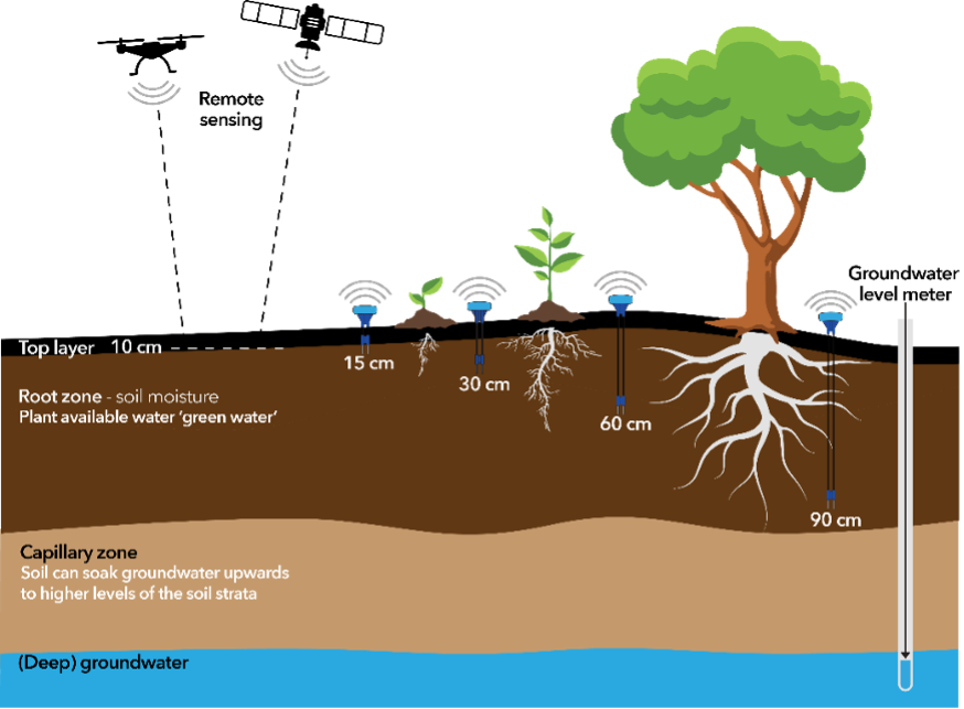
Soil moisture availability can be estimated through remote sensing (satellite imagery) and/or modeling based on groundwater levels. Yet remote sensing is only covering the top 10 to 15 centimeters of the soil. And when the satellite detects that a plant is dry, the plant is already in stress. Not only that, remote sensing shows us the past. Not only that, it is possible that the satellite does not have a clear pass because of cloud cover. This means that remote sensing is ideal to analyze larger areas and longer time periods, but aways in retrospect. Satellite imagery is also very useful for determining where to install local soil moisture sensors.
Measuring groundwater
Groundwater monitoring is very common and very important, but it only gives an indirect indication of soil moisture percentages. The groundwater level is often several meters down and if it is used to calculate an estimation of soil moisture. This is always based on modeling. A key disadvantage is that most of the time, these models do not consider local differences. And groundwater is not a good indicator for soil moisture levels at the root zone, which is available for plants. Capillary function of the soil influences soil moisture levels. Capillary function changes based on the by soil type and soil horizon, and influences the actual soil moisture percentage.
Measuring at the Root Zone
Looking at the below picture, it is clear that the place where plants and trees get their water from – the root zone – is exactly between the top layer of the soil, and the groundwater level.
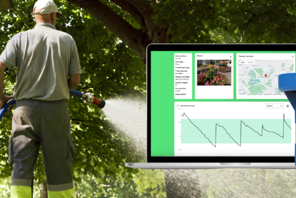
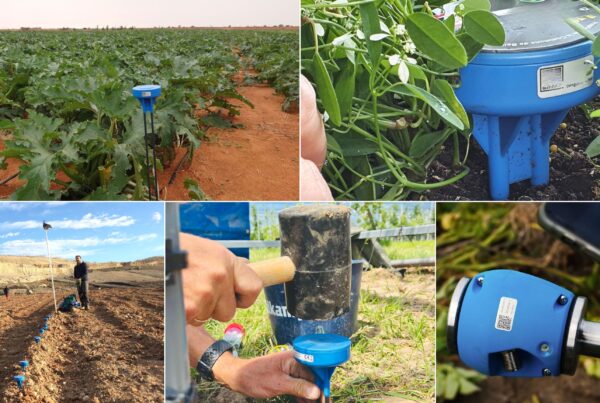
In situ data points
To measure the percentage of soil moisture in the root zone, Single Depth or Multi Depth sensors can be used. The key advantage of Single Depth sensors is that they are not expensive, and they provide precise insights at the desired depth. Due to the potential local differences in soil moisture, it’s better to have a higher data point frequency for better insights. This can be achieved by installing more (affordable) sensors across a field/area, rather than relying on one, or a limited number of pricy sensors. The length (or depth) of a Single Depth sensor is determined by the crop type or tree species. When the right length is chosen, it tells you exactly what the soil moisture percentage is, where it’s the most important.
A Multi Depth sensor can be used to get a better understanding of the soil moisture profile, and of the ‘movement’ of water through the soil layers. For example, this helps to better understand the capillary function of the soil. We often see a combination of Single Depth and Multi Depth sensors in projects. Not only that, but Multi Depth sensors can even be used to determine at which depth the soil moisture should be measured, so it can be replaced with a Single Depth sensor.
Integrating data for actionable insights
All in all, there is value in each type of measurement: local (in situ) soil moisture sensors, remote sensing, and groundwater level monitoring. There is no one way, and one measurement type does not exclude the other. For example, satellite imagery can be used to determine where to place soil moisture sensors, and the data from these sensors can be used to train and validate models. Also, soil moisture sensors are a very good addition to groundwater level monitoring.
About Sensoterra
Sensoterra is a pioneering leader in the field of wireless soil moisture sensors, offering cutting-edge IoT soil moisture sensor solutions for smart agriculture. Our state-of-the-art Sensoterra soil moisture sensors are at the forefront of agriculture IoT, providing unparalleled soil moisture monitoring capabilities.
Our commitment to precision agriculture technology allows farmers to make informed decisions, optimize their irrigation systems, and embrace sustainable farming solutions. With Sensoterra, access to real-time soil moisture data is at your fingertips, enabling precise water management and water resource management for your agricultural operations.
Sensoterra, established in 2015, with its headquarters in Houten, The Netherlands, develops water management solutions for agriculture/horticulture, smart city management, and water governance. Sensoterra has over 12,000 sensors in the ground globally, and generates hundreds of thousands of data points for smart water management, daily. Learn more at www.sensoterra.com
Contact for more information, pictures and/or interview requests:
Jessica Nuboer
Marketing & Communications
Sensoterra
Email: [email protected]